Friday, March 29, 2013

Boxing day Tsunami

Overview

On Boxing Day 2004 a magnitude 9.0 earthquake triggered the sudden upthrust of 1000 km of convergent plate boundary as shown below.  As the plate pushed upwards, it also pushed the water above it upwards.  Given that the water depth was between 5000 - 7500 meters, it generated tsunamis along the coastlines of many nations in the Indian Ocean


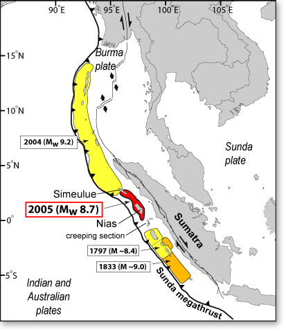
Given the proximity of the coast to the earthquake site , Indonesia and Banda Aceh suffered the most.  Up to 200,000 people were recorded dead or missing.  Other countries (Thailand, Sri Lanka, and India) lost tens of thousands of people.  The wave reached as far as Africa where over 300 were killed.

Because this is a case study I am not going to spend to much time writing about what happened in individual countries.  Things to consider are:

  1. Damage to buildings
  2. Damage to infrastructure (sewerage, water supply, roads, ports etc)
  3. Release of polluting chemicals if industrial areas were struck by the wave
  4. Contamination of groundwater supplies that may have been used for drinking.
  5. Loss of reefs and mangroves which may have acted a fish nurseries
  6. Saltwater pollution on land


While earthquakes are difficult to predict (especially those underwater), and impossible to stop, one piece of technology can be deployed to save lives.  The DART (Deep ocean Assessment and Recording of Tsunamis) can detect an oncoming tsunami and evacuation orders can be given if required.  


figure-4-dart-ii-system-communications.png

Following the Boxing Day tsunami, efforts have increased to deploy these systems into the Indian Ocean.

DART Buoys 


Saturday, March 23, 2013

Poisonous gas emissions and lahars

Poison gas - Lake Nyos 1987   

As this region of Africa has been subject to rifting the area was volcanic. Lake Nyos is a crater lake that appears to have gas rising out of the magma from below the crater.  While the volcano is considered to be inactive, there is a large pool of magma below it.   On 1987 triggered by either an earthquake or landslide, a large volume of carbon dioxide and sulphur oxides. to be released from the lake. The analogy could be thought of a stirring a glass of Coke with a spoon.  In the surrounding villages, 1700 people and their livestock died.  One of the few survivors said that even the flies that normally come to a body were dead as well.


Subsequent analysis of the lake found that is extremely high in dissolved carbon dioxide due to its depth (up to 200 meters).  Since then efforts have been underway to degas the lake so that this does not happen again. 


The pipe is near the bottom and the pressure of the dissolved gases forcing themselves up the pipe is strong enough to cause a plume of water and gas at the surface.


Lahars - Amero (1985)

The town of Amero had a population of approximately 30,000 in 1985.  When the volcano Nevada del Ruis had a small eruption on 13th November 1985, it instantly melted a portion of the glacier that sat on the top of the mountain.  The huge volume of water combined with the loose ash on the sides of the mountain, and raced towards the town of Amero. 


Nearly all the town was affected and 23,000 perished. The town could have been evacuated but volcano was obscured by clouds and the government were reluctant to evacuate due to pressure from locals concerned about their property values.


The town has essentially been abandoned and 20,000 were left displaced from the event.  The area has been left with volcanic mud that has set like concrete.  Nearly all those who were buried were left there.  Given time this area will become fertile farming land as it was before, but it could still be prone to future lahars.

Tuesday, March 19, 2013

Pyroclastic flows and lava

Damage from lava


Heimaey 1973

In 1973 the Edfell volcano erupted behind the town of Heimay in Iceland.


Initially the town was covered in ash, but soon after this lava began to flow down into the town and the harbour.  Houses that had lava flow into them were set on fire and eventually pushed over.  Concern mounted over the harbour being sealed off because of its fishing industry, the major employer of the town.  All efforts were put into trying to divert the lava flow from entering the harbour entrance and thus keep it open.  By using every available pump and fire hose, the lava was cooled and eventually diverted.  However, 300 homes were lost to lava flows and another 80 collapsed under the weight of the ash.  No lives were lost due to an emergency plan well executed.

The eruption lasted 4 months and extended the island considerably.

One of the problems of lava is dealing with the immense heat and flows.  It is not always possible to divert lava flows but luckily for Heimay, the towns engineers succeeded.


Pyroclastic Flow


Mt Unzen Japan (1991)/Mt Pinatoubo (1991)


In November of 1989, an earthquake swarm broke nearby and continued throughout the succeeding year. In May of the following year (1991), fresh lava began to emerge. This forced authorities to order the evacuation of some 12,000 residents. Despite the precautionary measures made against it, the volcano managed to claim 43 lives when it eventually erupted.


A pyroclastic flow is a mixture of solid to semi-solid fragments and hot, expanding gases that flows down the flank of a volcano.  The gases contain sulphur oxides, carbon dioxide which are fatal if inhaled in significant quantities. Pyroclastic flows are heavier-than-air and move much like a snow avalanche, except that they are extremely hot, contain toxic gases, and move at often over 100 km/hour. They can travel up to 50 km away from the site of volcanoes that produce them.


They are the most deadly of all volcanic phenomena.  Pyroclastic flow killed the French volcanologists Katia and Maurice Kraftt when Mount Unzen erupted. A Japanese colleague described Maurice's body as being completely carbonised (turned into carbon) from the immense temperatures.


Why live near volcanic zones?

Close to an erupting volcano the short-term destruction by pyroclastic flows, heavy falls of ash, and lava flows can be complete, the extent of the damage depending upon the eruption magnitude. Crops, forests, orchards, and animals grazing or browsing on the volcano's slopes or surrounding lowland can be leveled or buried. But that is the short-term effect. In the long run, volcanic deposits can develop into some of the richest agricultural lands on earth.

One example of the effect of volcanoes on agricultural lands is in Italy. Except for the volcanic region around Naples, farming in southern Italy is exceedingly difficult because limestone forms the basement rock and the soil is generally quite poor. But the region around Naples, which includes Mount Vesuvius, is very rich mainly because of two large eruptions 35,000 and 12000 years ago that left the region blanketed with very thick deposits of ash and rock which has since weathered to rich soils. Part of this area includes Mount Vesuvius. The region has been intensively cultivated since before the birth of Christ. 


The fertility of many farmlands of the North Island of New Zealand are due to volcanic soils of different ages. These have developed on older (4,000 and 40,000 years old) volcanic ash deposits of the Waikato and Bay of Plenty regions. Combined with ample rainfall, warm summers, and mild winters, these regions produce abundant crops.


Another thing that volcanic mountains and mountain ranges do is enhance local rainfall if the conditions are in its favour.  Moist air flows are pushed into cooler areas which the condense and fall back as rain.  Combined with the rich soils, food production can be very high in these areas.

Monday, March 4, 2013

The Tectonic Supercycle

The tectonic supercycle (also known as the Wilson cycle) describes the movement of continents where they congregate to fora a supercontinent, break up, and eventually rejoin again to form a new supercontinent.  The last supercontinent was Pangaea   The breakup of this continent was thought to have occurred about 250 million years ago.  The supercontinent Rodinia was thought to have begun forming 1100 million years ago and appears to have broken up about 750 million years ago.

Parts of Western and Central Australia were in the northern hemisphere when Rodinia was formed, but much of Australia as we know it already existed in the southern regions of Pangaea.  Continental drift over long periods of time has help explain this crossing of the hemispheres.


The cycle is as follows:

  1. A stable cration (geologically stable region) begins rifting and pulling apart (African Rift valley)
  2. Over time the extent of rifting allows for the ocean to flood in. Two new continents are made (South America and Africa, separated by the Atlantic Ocean)  
  3. Eventually the denser oceanic lithosphere begins to get pushed under the continental lithosphere, causing a subduction zone to form.
  4. As the subduction continues, an accretionary wedge and volcanic activity add land to this area.  The gap between the continents decreases.
  5. Eventually the 2 continents collide, forming fold mountains.  Eventally motion stops.  
  6. Erosion flattens the mountain and the craton becomes stabilised.