Sunday, April 21, 2013

Volcanoes and Climate

Laki 1783-84

 The Laki eruption started in  June 1783 and lasted for 8 months.  A cloud of sulphur dioxide moved over Europe causing a higher than normal rate of death in outdoor workers.  When the winter of 1784 started, it was extremely severe, with the duration of the season being excessively long (snowfall throughout April) and very cold.  The effects of this were also felt in North America.  This eruption, while not explosive, produced a massive amount of sulphur dioxide.  In the stratosphere, sulphur dioxide combines with water and oxygen to for sulphuric acid.  The sulphuric acid aerosol is extremely reflective, meaning that incoming light is reflected back into space rather than reaching Earth.


The effects of the Laki eruption on winter temperature can be seen to have lasted for a few years afterwards.


Tambora 1815

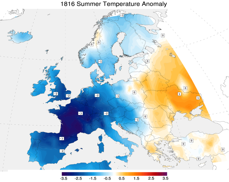
The eruption of Mt Tambora in Indonesia is thought to be the largest volcanic event in recorded human history.  The expolsion itself is thought to have directly contributed to 75,000 deaths.  The effects on the climate were dramatic.  The year of 1816 was described at the year without summer.  In the northern parts of the USA, snow fell in June and July, crops failed due to frost damage and hunger became widespread.  The effects on Europe are shown below.


File:1816 summer.png


Mt Pinatubo 1991

The June 1991 explosion of Mt Pinatubo ejected a large quantity of ash and sulphur dioxide into the atmosphere.  Apart from the effects of sulphur dioxide, the ash scatters some of the incoming light and heat from the sun, preventing it from reaching the ground.  The dispersal of the sulphur dioxide from the eruption can be seen below.


Following this eruption, the following changes to climate were observed.

A study performed by NASA combined the data from 4 large volcanic eruptions with climate showed to what extent such eruptions have on the climate,


Intraplate Earthquakes

While Australia sits in the middle of a tectonic plate, this merely considers the major fault lines of the globe.  Australia has a number of minor fault lines, or areas of relative crustal weakness, as a result of the events involved in its formation ranging from 2.5 billion years ago to 50 million years ago.

In addition, the forces placed on the Australian continent as a result of being "pushed" by divergent plate activity to the south and "pulled" by convergent activity to the north are not uniform.  As a result, areas of localised stress will build up over time.  When released, they cause intraplate earthquakes.

Intraplate earthquakes are generally shallow, infrequent and have lower magnitudes compared to those located at plate boundaries.  The earthquake risks of Australia are shown on the map directly below.  The closer the lines, the greater the risk.


This coincides quite well with the measured earthquakes in Australia's history over the last 100 years or so. 


2 earthquakes of note in recent Australian history occurred at Meckering in 1968 and Newcastle in 1989.  The Meckering quake, was 6.9 in magnitude and while no deaths occurred, a 40 km rupture appeared along the ground and the ground was thrust upwards by 2 meters in some places.


On Dec. 28, 1989, a 5.6 magnitude earthquake struck Newcastle. 13 people died including 9 in the Newcastle workers club (pictured below).  300 buildings were eventually demolished and the damage bill has been calculated at $5 billion.  A number of older buildings such as the local high school and parts of John Hunter Hospital had to be rebuilt.  The reason for this was because many of the structural walls were sunk into the ground when constructed, and as a result, suffered significant damage.  The age of many buildings was also a significant factor in the extent of the damage. 

The Newcastle Workers Club was hit hard in the 1989 earthquake. (Credit: City of Newcastle)


Kobe Earthquake of 1995

In Kobe on January 17 1995, a magnitude 7.2 earthquake struck, resulting in over 6000 deaths and hundreds of billions of dollars damage.  Some of the reasons for this are described below.

Traditional Japanese housing design.  In the older parts of Kobe, many of the houses have heavy tiled roofs that are supported by wooden beams (usually at the corners).  The walls offer little to no structural support at all to these.  As a result the roof falls and crushes all below in a pancake collapse. 


Breakage of gas lines and use of charcoal braziers.  The use of charcoal cookers in some houses started fires during and after the earthquake.  Ruptured gas lines increased the scale of the fires as the night progressed.
Firefighters were unable to successfully fight the fires due to broken water pipes and/or reach the areas due to blocked roads.


Despite being considered adequate for earthquakes when constructed, some of Kobe's overhead freeways collapsed.  This was put down to inadequate steel reinforcing of the pylons that supported them.


The dock area was built on reclaimed land in the harbour.  The earthquake redistributed the sand and water that the docks were sitting on, resulting in significant liquefaction and subsidence.


As described in the figure below, the soil sinks and the water rises.  As the soil sinks the subsidence occurs, resulting building damage ans water levels changing.

Effects of Earthquakes on Built and Natural Structures

This will be 2 parts.  One will look at esrthquake damage in general, and then more specifically at the damage caused to built structures using the 1995 Kobe earthquake as an example.

Sometimes as a result of earthquakes, ruptures will appear above ground with sudden rises or falls of land.  These are called scarps and can vary in height.

surface rupture, called a scarp, formed in just seconds along the Borrego fault

Earthquakes can trigger landslides.  In Hati, the 2010 earthquake caused many landslides along the coast.  Below is an example of this.


Landslides risks are increased if the land is cleared.  Below is a photo of a village in El Salvador.

Landslide in San Salvador, El Salvador, resulting from a powerful earthquake. PHOTOGRAPH REPRODUCED BY PERMISSION OF THE CORBIS CORPORATION.

Following the 1964 earthquake in Alaska, a number of waterways had to be resurveyed due to landslides, subsidence and upthrusts which altered the depth of previously navigable waterways to the point that they posed hazards to boat traffic.


When it comes to built structures, earthquake damage will cause the most deaths and injuries when buildings collapse.  In many developing nations, cheap high density buildings are mostly concrete based.  While strong, concrete is brittle, and so collapse often occurs if it has no reinforcing steel in the structure.  The steel being malleable can withstand the shaking and stops the concrete from breaking as frequently.


Earthquakes can also cause serious damage to infrastructure like the railway pictured here.  It can also break water and sewage pipes (resulting in sanitation and health problems), cause electricity disruption, and break gas pipes (which pose a fire hazard).  Some of these are discussed in the Kobe earthquake post.


Friday, March 29, 2013

Boxing day Tsunami

Overview

On Boxing Day 2004 a magnitude 9.0 earthquake triggered the sudden upthrust of 1000 km of convergent plate boundary as shown below.  As the plate pushed upwards, it also pushed the water above it upwards.  Given that the water depth was between 5000 - 7500 meters, it generated tsunamis along the coastlines of many nations in the Indian Ocean


Given the proximity of the coast to the earthquake site , Indonesia and Banda Aceh suffered the most.  Up to 200,000 people were recorded dead or missing.  Other countries (Thailand, Sri Lanka, and India) lost tens of thousands of people.  The wave reached as far as Africa where over 300 were killed.

Because this is a case study I am not going to spend to much time writing about what happened in individual countries.  Things to consider are:

  1. Damage to buildings
  2. Damage to infrastructure (sewerage, water supply, roads, ports etc)
  3. Release of polluting chemicals if industrial areas were struck by the wave
  4. Contamination of groundwater supplies that may have been used for drinking.
  5. Loss of reefs and mangroves which may have acted a fish nurseries
  6. Saltwater pollution on land


While earthquakes are difficult to predict (especially those underwater), and impossible to stop, one piece of technology can be deployed to save lives.  The DART (Deep ocean Assessment and Recording of Tsunamis) can detect an oncoming tsunami and evacuation orders can be given if required.  


figure-4-dart-ii-system-communications.png

Following the Boxing Day tsunami, efforts have increased to deploy these systems into the Indian Ocean.

DART Buoys 


Saturday, March 23, 2013

Poisonous gas emissions and lahars

Poison gas - Lake Nyos 1987   

As this region of Africa has been subject to rifting the area was volcanic. Lake Nyos is a crater lake that appears to have gas rising out of the magma from below the crater.  While the volcano is considered to be inactive, there is a large pool of magma below it.   On 1987 triggered by either an earthquake or landslide, a large volume of carbon dioxide and sulphur oxides. to be released from the lake. The analogy could be thought of a stirring a glass of Coke with a spoon.  In the surrounding villages, 1700 people and their livestock died.  One of the few survivors said that even the flies that normally come to a body were dead as well.


Subsequent analysis of the lake found that is extremely high in dissolved carbon dioxide due to its depth (up to 200 meters).  Since then efforts have been underway to degas the lake so that this does not happen again. 


The pipe is near the bottom and the pressure of the dissolved gases forcing themselves up the pipe is strong enough to cause a plume of water and gas at the surface.


Lahars - Amero (1985)

The town of Amero had a population of approximately 30,000 in 1985.  When the volcano Nevada del Ruis had a small eruption on 13th November 1985, it instantly melted a portion of the glacier that sat on the top of the mountain.  The huge volume of water combined with the loose ash on the sides of the mountain, and raced towards the town of Amero. 


Nearly all the town was affected and 23,000 perished. The town could have been evacuated but volcano was obscured by clouds and the government were reluctant to evacuate due to pressure from locals concerned about their property values.


The town has essentially been abandoned and 20,000 were left displaced from the event.  The area has been left with volcanic mud that has set like concrete.  Nearly all those who were buried were left there.  Given time this area will become fertile farming land as it was before, but it could still be prone to future lahars.

Tuesday, March 19, 2013

Pyroclastic flows and lava

Damage from lava


Heimaey 1973

In 1973 the Edfell volcano erupted behind the town of Heimay in Iceland.


Initially the town was covered in ash, but soon after this lava began to flow down into the town and the harbour.  Houses that had lava flow into them were set on fire and eventually pushed over.  Concern mounted over the harbour being sealed off because of its fishing industry, the major employer of the town.  All efforts were put into trying to divert the lava flow from entering the harbour entrance and thus keep it open.  By using every available pump and fire hose, the lava was cooled and eventually diverted.  However, 300 homes were lost to lava flows and another 80 collapsed under the weight of the ash.  No lives were lost due to an emergency plan well executed.

The eruption lasted 4 months and extended the island considerably.

One of the problems of lava is dealing with the immense heat and flows.  It is not always possible to divert lava flows but luckily for Heimay, the towns engineers succeeded.


Pyroclastic Flow


Mt Unzen Japan (1991)/Mt Pinatoubo (1991)


In November of 1989, an earthquake swarm broke nearby and continued throughout the succeeding year. In May of the following year (1991), fresh lava began to emerge. This forced authorities to order the evacuation of some 12,000 residents. Despite the precautionary measures made against it, the volcano managed to claim 43 lives when it eventually erupted.


A pyroclastic flow is a mixture of solid to semi-solid fragments and hot, expanding gases that flows down the flank of a volcano.  The gases contain sulphur oxides, carbon dioxide which are fatal if inhaled in significant quantities. Pyroclastic flows are heavier-than-air and move much like a snow avalanche, except that they are extremely hot, contain toxic gases, and move at often over 100 km/hour. They can travel up to 50 km away from the site of volcanoes that produce them.


They are the most deadly of all volcanic phenomena.  Pyroclastic flow killed the French volcanologists Katia and Maurice Kraftt when Mount Unzen erupted. A Japanese colleague described Maurice's body as being completely carbonised (turned into carbon) from the immense temperatures.


Why live near volcanic zones?

Close to an erupting volcano the short-term destruction by pyroclastic flows, heavy falls of ash, and lava flows can be complete, the extent of the damage depending upon the eruption magnitude. Crops, forests, orchards, and animals grazing or browsing on the volcano's slopes or surrounding lowland can be leveled or buried. But that is the short-term effect. In the long run, volcanic deposits can develop into some of the richest agricultural lands on earth.

One example of the effect of volcanoes on agricultural lands is in Italy. Except for the volcanic region around Naples, farming in southern Italy is exceedingly difficult because limestone forms the basement rock and the soil is generally quite poor. But the region around Naples, which includes Mount Vesuvius, is very rich mainly because of two large eruptions 35,000 and 12000 years ago that left the region blanketed with very thick deposits of ash and rock which has since weathered to rich soils. Part of this area includes Mount Vesuvius. The region has been intensively cultivated since before the birth of Christ. 


The fertility of many farmlands of the North Island of New Zealand are due to volcanic soils of different ages. These have developed on older (4,000 and 40,000 years old) volcanic ash deposits of the Waikato and Bay of Plenty regions. Combined with ample rainfall, warm summers, and mild winters, these regions produce abundant crops.


Another thing that volcanic mountains and mountain ranges do is enhance local rainfall if the conditions are in its favour.  Moist air flows are pushed into cooler areas which the condense and fall back as rain.  Combined with the rich soils, food production can be very high in these areas.

Monday, March 4, 2013

The Tectonic Supercycle

The tectonic supercycle (also known as the Wilson cycle) describes the movement of continents where they congregate to fora a supercontinent, break up, and eventually rejoin again to form a new supercontinent.  The last supercontinent was Pangaea   The breakup of this continent was thought to have occurred about 250 million years ago.  The supercontinent Rodinia was thought to have begun forming 1100 million years ago and appears to have broken up about 750 million years ago.

Parts of Western and Central Australia were in the northern hemisphere when Rodinia was formed, but much of Australia as we know it already existed in the southern regions of Pangaea.  Continental drift over long periods of time has help explain this crossing of the hemispheres.


The cycle is as follows:

  1. A stable cration (geologically stable region) begins rifting and pulling apart (African Rift valley)
  2. Over time the extent of rifting allows for the ocean to flood in. Two new continents are made (South America and Africa, separated by the Atlantic Ocean)  
  3. Eventually the denser oceanic lithosphere begins to get pushed under the continental lithosphere, causing a subduction zone to form.
  4. As the subduction continues, an accretionary wedge and volcanic activity add land to this area.  The gap between the continents decreases.
  5. Eventually the 2 continents collide, forming fold mountains.  Eventally motion stops.  
  6. Erosion flattens the mountain and the craton becomes stabilised.

Saturday, February 23, 2013

Plate Boundaries

Divergent plates

Divergent plates are where the upwelling of magma at tectonic plate boundaries causes lava to be extruded and pulls the 2 plates apart.  This part of the lithosphere contains mafic rock (high in iron and magnesium) from vulcanism and include basalt and gabbro.  Plate divergence is generally occurring under the sea, with the notable exception if Africa's rift valley and Iceland.


Oceanic oceanic convergent plates

This takes place were 2 oceanic lithospheric plates collide to form island arcs. Examples of these include Japan, Indonesia and The Phillipines.


The older cooler plate gets subducted due to its slightly higher density.  As the plate sinks sediments and water are also subducted.  This lowers the melting temp of the rock.  When it melts, the sediment and water may be incorporated into the rock altering its chemistry.  The pressure of the molten rock mixed with water forces it upwards where it erupts forming the island arcs.  Rock such as granite and rhyolite can be formed at these volcanoes.  These are termed felsic rocks.  These are lower in iron and magnesium, but higher in silica.


Continental oceanic convergent plates
When continental plate encounters a oceanic plate the oceanic plate is subducted.  Rather than forming a island arc, these plates form a line of volcanic mountain ranges near the coastline.  Examples of these are the Andes in South America and the Cascade mountains in the USA.  Rock types produced from this activity is the same as those in oceanic-oceanic boundaries.


Continental Continental convergent plates
When 2 continents collide fold and thrust mountains will occur.  This is caused by the compressional forces generated when the 2 continents are pushed together.  There is no volcanic activity in these plates so no new igneous rock is formed.  However frequent earthquakes occur due to the buildup and sudden releases of pressure on these rocks.


Transverse faulting

This occurs where 2 plates are moving in opposite directions relative to each other.  There is no volcanic activity, but earthquakes can be frequent and sometimes strong.  The figures below shows movement of trees in an orchid and fencposts relative to each other from slippages of the San Andreas Fault.


Lithospheric plates


Lithospheric plates are regions of Earth's crust and upper mantle.  This is the rigid solid part of the Earth.  This solid surface is fractured into plates that move across a the plasticine like mantle.  The term plasticine refers to something a bit like plasticine that you may be familiar with in your younger years.  While it's generally regarded as reasonably solid, it moves very slowly like extremely thick and viscous honey.  


There are 2 types of crust on the lithosphere, oceanic and continental.  Oceanic lithosphere is slightly denser and is up to 100 km thick.  Continental lithosphere is thicker (up to 150 km) and is made up of less dense rock.

Friday, February 22, 2013

Mine site rehabilitation. Mount Owen complex

The Mount Owen complex is made up of three sites and back onto Ravensworth state forest.  It is an open cut coal mine.  To ensure the environmental integrity of the area is restored by the end of mining operations, the following steps need to be undertaken.


1. A flora and survey needs to be done.

2. Topsoil is removed and and stored.

3. Spoil (rocks and deeper soil removed to access the coal) is stored in dumping areas.  

3. Following the exhaustion of this open cut mine, the spoil is placed back in the excavated areas.  Any remaining coal must be completely buried so that a bush fire does not ignite a seam of remaining underground coal and travel underground.

4.  The topsoil is then placed on top.  The existing seeds in the soil can be used to regenerate the area or deliberate replanting of the area with vegetation identified with the initial flora and fauna survey can be used.

5.  Revegetation may be a multi-staged work.  In some instances grass can be quickly established to stabilise the soil, followed by tree planting to restore the old vegetation. 

6.  Once completed, the area will need to be monitored over an extended period to ensure that regrowth is following projections and that native fauna is returning.


Mt Owen Revegetation 567 x 372


A summary of the whole process is below.