Saturday, February 23, 2013

Plate Boundaries

Divergent plates

Divergent plates are where the upwelling of magma at tectonic plate boundaries causes lava to be extruded and pulls the 2 plates apart.  This part of the lithosphere contains mafic rock (high in iron and magnesium) from vulcanism and include basalt and gabbro.  Plate divergence is generally occurring under the sea, with the notable exception if Africa's rift valley and Iceland.


Oceanic oceanic convergent plates

This takes place were 2 oceanic lithospheric plates collide to form island arcs. Examples of these include Japan, Indonesia and The Phillipines.


The older cooler plate gets subducted due to its slightly higher density.  As the plate sinks sediments and water are also subducted.  This lowers the melting temp of the rock.  When it melts, the sediment and water may be incorporated into the rock altering its chemistry.  The pressure of the molten rock mixed with water forces it upwards where it erupts forming the island arcs.  Rock such as granite and rhyolite can be formed at these volcanoes.  These are termed felsic rocks.  These are lower in iron and magnesium, but higher in silica.


Continental oceanic convergent plates
When continental plate encounters a oceanic plate the oceanic plate is subducted.  Rather than forming a island arc, these plates form a line of volcanic mountain ranges near the coastline.  Examples of these are the Andes in South America and the Cascade mountains in the USA.  Rock types produced from this activity is the same as those in oceanic-oceanic boundaries.


Continental Continental convergent plates
When 2 continents collide fold and thrust mountains will occur.  This is caused by the compressional forces generated when the 2 continents are pushed together.  There is no volcanic activity in these plates so no new igneous rock is formed.  However frequent earthquakes occur due to the buildup and sudden releases of pressure on these rocks.


Transverse faulting

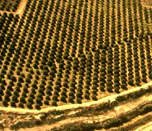
This occurs where 2 plates are moving in opposite directions relative to each other.  There is no volcanic activity, but earthquakes can be frequent and sometimes strong.  The figures below shows movement of trees in an orchid and fencposts relative to each other from slippages of the San Andreas Fault.


Lithospheric plates


Lithospheric plates are regions of Earth's crust and upper mantle.  This is the rigid solid part of the Earth.  This solid surface is fractured into plates that move across a the plasticine like mantle.  The term plasticine refers to something a bit like plasticine that you may be familiar with in your younger years.  While it's generally regarded as reasonably solid, it moves very slowly like extremely thick and viscous honey.  


There are 2 types of crust on the lithosphere, oceanic and continental.  Oceanic lithosphere is slightly denser and is up to 100 km thick.  Continental lithosphere is thicker (up to 150 km) and is made up of less dense rock.

Friday, February 22, 2013

Mine site rehabilitation. Mount Owen complex

The Mount Owen complex is made up of three sites and back onto Ravensworth state forest.  It is an open cut coal mine.  To ensure the environmental integrity of the area is restored by the end of mining operations, the following steps need to be undertaken.


1. A flora and survey needs to be done.

2. Topsoil is removed and and stored.

3. Spoil (rocks and deeper soil removed to access the coal) is stored in dumping areas.  

3. Following the exhaustion of this open cut mine, the spoil is placed back in the excavated areas.  Any remaining coal must be completely buried so that a bush fire does not ignite a seam of remaining underground coal and travel underground.

4.  The topsoil is then placed on top.  The existing seeds in the soil can be used to regenerate the area or deliberate replanting of the area with vegetation identified with the initial flora and fauna survey can be used.

5.  Revegetation may be a multi-staged work.  In some instances grass can be quickly established to stabilise the soil, followed by tree planting to restore the old vegetation. 

6.  Once completed, the area will need to be monitored over an extended period to ensure that regrowth is following projections and that native fauna is returning.


Mt Owen Revegetation 567 x 372


A summary of the whole process is below.


Wednesday, February 13, 2013

Stormwater Treatment.

The example given for you was Lake Macquarie on the Central coast of NSW.  Recent and rapid urban development caused urban erosion due to land clearing, increased impermeable surfaces and outdated stormwater drains were causing erosion. 


The immediate concern of the local council was to reduce the sediments being transported into the lake from the creeks and streams and the erosion occurring on the sides of the lake.

Powerful own on the Green Point walk - Picture of Lake Macquarie, Lake Macquarie


Revegetation was part of the solution to try and stop erosion from happening in the first place, but the most effective step appears to have been the construction of artificial wetlands.  These work for a number of reasons.

  1. They slow the flow of water down reducing its potential to cause erosion.
  2. Slowing the water down also allows sediments to fall out before they reach the lake
  3. Plants in the wetlands also absorb nutrients and thus improve the quality if the water entering the lake.
This is an image of a group of people. Lake Macquarie Council now considers Landcare to be core business.

Artificial wetlands also protect the lake oven when overflowing in heavy rain by reducing sediment flow into the main waterway.  Even though their capacity to remove nutrients and pollutants is greatly reduced, they continue to slow water down so that it is not able to carry as much sediment into the lake.

Environmental Flows and River Health


There have been 2 well known rivers in NSW that have had significant alterations to their health as a result of damming and water diversion for agriculture.  One is the  Snowy river and the other is the Murray-Darling.  We will concentrate on the Snowy River.

As a result of the Snowy hydroelectric scheme, water flows of the Snowy River fell by 95-99%.  Because of this severe degradation, the river had silted up, weeds and feral plants were established, and the fish life was dying out. Scientists had established that it would take 28% of the original flows to restore the river back to good health.


In the late 1990's the NSW and Victorian governments agreed to release this water into the river, gradually increasing it to the 28% level about a decade later.  The drought from 2000-8 caused the governments to hesitate because water was being diverted to agriculture.

Eventually court action by local environment groups force the release of water in 2011.  Water is released seasonally as to mimic the spring snowmelt and copy the behavior of the river in a natural state.  This cylce of large and rapid releases has cleared the river of a lot of the silt and debris, and it is hoped that indigenous water fauna will now return.


A YouTube link is below:

www.youtube.com/watch?v=55WUBhBibkw

Regulation of Water in NSW


Why is water regulated so heavily in Australia and NSW?
1. Maintain water quality for all users
2. Allow time for recharge of  bore water supplies
3.Reduction of feral animals/weeds
4.Water flows can be seasonal or variable depending on whether the area is in drought or not.
5.Ensures that the environment in and around waterways is not degraded, resulting in further declines of water quality

As a result, if you capture more than 10% of the total rainfall on your property (rural, and feeding into a creek or river), you need a water license. If you draw on a waterway on or adjacent to your property you need a license.  If you take water from under your property you should have a license.

Licences were issues on a 15 year basis in 2002.  They are non transferable to other rivers etc and will be renewed on application.  They can be bought and sold on the market.  Once sold, you lose your right to take water other than rainfall.  The allocated water is measured from a meter attached to pumps or pipes.  Any meter tampering results in immediate  loss of license.  Excess water consumption one year may lead reductions in allocated water the next year.